-2.png?height=120&name=Ozen%20Long%20-%20Back%20(1)-2.png)
- Help Center
- ANSYS AEDT
-
Getting Started With Ansys
-
Ansys Installation
-
Licensing
-
Ansys Mechanical
-
ANSYS AEDT
-
Ansys Maxwell
-
Ansys HFSS
-
Ansys CFD
-
CAD
-
Meshing
-
LS-Dyna & LS-Prepost
-
SpaceClaim
-
Ensight
-
Ansys Lumerical
-
Zemax
-
Discovery
-
AUTODYN
-
Workbench
-
Ansys EMC Plus
-
SIwave
-
CFD-Post
-
Ansys Sherlock
-
Q3D
-
Ansys 3D Layout
-
Fluent Meshing
-
Thermal Desktop
-
Icepak
-
Ansys Icepak
-
Twin Builder
-
Fluent
-
AEDT Circuit
-
EMA3D
-
Linux
-
Optislang
-
Motor-CAD
-
Ansys CFX
How to export field values on the surface of an object along with coordinates
Export field values on the surface along {x,y,z}
Solution:
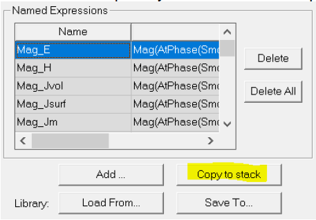
Field values on the surface of an object can be exported along with the coordinates using the Fields Calculator as follows:- Select the field quantity from the ‘Named Expressions’, for e.g. Mag_E.
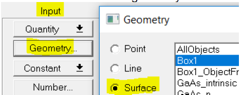
- Select the surface of the geometry
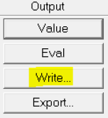
- From the Output stack, choose ‘Value’.

This will create the expression
- From the Output stack, select ‘Write…’ and specify the file name in the pop-up window to save the *.fld file which will contain 4 column data with coordinates followed by the value i.e. {x, y, z, f(x,y,z)}.